
Tuvalu (English spelling)

|
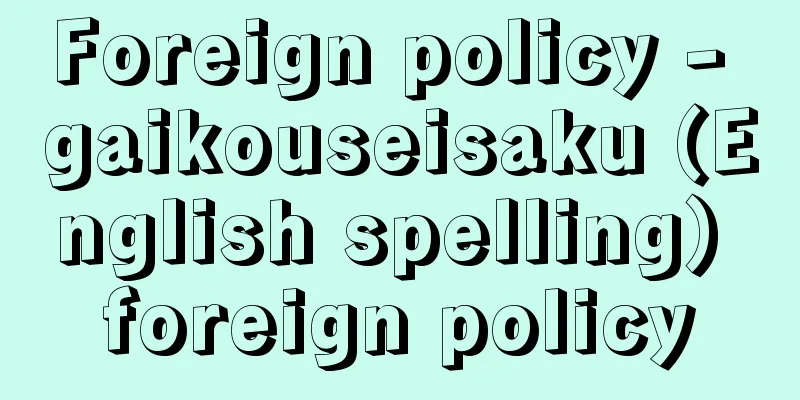
Located just south of the equator in the Southern Hemisphere, this small island nation borders the west side of the International Date Line. During the British colonial period, it was part of the Gilbert and Ellice Islands, which became the independent state of Tuvalu. The total land area of the country, which consists of nine atoll islands, is only 26 square kilometers, making it the fourth smallest in the world after neighboring Nauru. It has a population of 10,000 (estimated in 2005) and 11,126 (2007, Tuvalu government statistics). In 1978, it separated from the Gilbert Islands and became independent. As discussions of global warming became more active in the 21st century, it became known as an island in danger of being submerged, attracting worldwide attention. The capital is Funafuti (Fongafale Island in Funafuti Atoll). [Izumi Kobayashi] Nature and GeographyThe nine islands scattered 560 km from north to south are all flat coral reef islands, with their highest points only a few meters above sea level. There is little land and the coral soil is not suitable for agriculture, so only a few edible plants such as bananas, coconut palms, and potatoes can grow, and the habitable population is limited. Funafuti Atoll, where the capital is located, is 3 square kilometers, and the largest crescent-shaped landmass within it is Fongafale Island, with an area of 0.88 square kilometers. This is the size of 19 Tokyo Domes, but half of the entire population lives here and they also raise more than 5,000 pigs. Furthermore, all of the capital's functions, such as the airport, government buildings, hospitals, and schools, are concentrated in this small space, making the city even more overcrowded than Japan. It has a tropical maritime climate, with a relatively high average annual rainfall of 3,000 mm. People's livelihoods depend on this rainwater and wells pumped from lens water (rainwater that has seeped into the reef and floats on top of the seawater in a thin lens shape due to differences in specific gravity) that accumulates under the atoll. Although it is located at the eastern edge of the Eastern Hemisphere, the inhabitants are culturally and ethnically Polynesian. The reason why Tuvalu separated from its neighboring country Kiribati (Gilbert Islands), which was under British colonial rule, was because of resistance to building a single nation with the Micronesians. The unity of the Polynesians gave the country its name, Tuvalu, which means "group of eight." There are nine islands, but the southernmost island, Niurakita, is uninhabited. [Izumi Kobayashi] historyThe first record of a Westerner landing on Nui Island was in 1568, when Spanish explorer Alvaro de Mendania discovered it. Other islands were discovered one after another, and in 1819, American explorer De Peister discovered Funafuti Atoll and named it Ellis Island after the shipowner. This area was the site of the slave trade in the mid-19th century, and has a history of men being forcibly migrated to Peru, Hawaii, Tahiti, etc. as laborers. In 1892, Britain made it a protectorate along with the Gilbert Islands, and in 1915 it was colonized as the Gilbert and Ellice Islands. A report from the time of British protectorate stated that most of Fongafale Island in Funafuti Atoll was marshland, with about 200 people living there. In 1942, during the Pacific War, the United States sent Marines to the marshland and constructed a runway on a simple filled-in landfill in just five weeks as an emergency measure to counter the Japanese army that had advanced into the neighboring Gilbert Islands. The main reason for making Fongafale Island the capital at the time of independence was that it had an airfield that served as a gateway to the rest of the country. In the 1970s, Britain implemented a policy of granting independence to its colonies in the Pacific Island region. The inhabitants of the Ellice Islands did not want to be separated from the Gilbert Islands, inhabited by Micronesians, so they voted to separate, and the Polynesian nation of Tuvalu was born in 1978. [Izumi Kobayashi] PoliticsThe government system is a constitutional monarchy with the Queen of England (King) as head of state, and a Tuvaluan Governor-General acting as her representative. The country has a parliamentary cabinet system, with a unicameral parliament with 15 seats, and members serve four-year terms. There are no political parties, and there is no political conflict within the country over differing policy lines, but political groups are easily formed based on regional interests and personal preferences, which makes the country's domestic politics unstable. The country is a member of the Commonwealth of Nations. In recent years, the country has attracted international attention as a country at risk of being submerged under water, and the prime minister is being asked to demonstrate his ability to secure aid from foreign countries and international organizations, and he is increasingly being given opportunities to actively promote Japan at various international conferences related to global environmental issues. Japan joined the United Nations in 2000, and has a permanent ambassador to the United Nations in New York, where the UN headquarters is located. [Izumi Kobayashi] Economy and SocietyTraditionally, the nation's national life was based on a self-sufficient, non-monetary economy, so tax revenues alone were not enough to maintain the nation's finances. Therefore, the main sources of government revenue are the investment income from trust funds, fishing fees within the exclusive economic zone, rental fees for the use of the domain code ".tv", income from postage stamps, and aid from abroad. The people make a living from salaries earned as civil servants or in government-related businesses, remittances from migrant workers, copra (dried endosperm of coconut palm fruit) and some income from fishing. Prices are high around the capital city, as most of the commodities for daily life are imported. According to UN data, the GNI (gross national income) per capita is $3,213 (2009), but since there is no significant industry in the country and the society is highly dependent on self-sufficient agriculture and fishing outside the capital area, it is difficult to grasp the actual economic situation from the cash income level. Rather, supported by primordial wealth (natural assets) and remittances, people's lives appear peaceful and even prosperous. However, the modernization path since independence is actually bringing anxiety and crisis to the country's future. The population of Funafuti, which was 871 in 1973, has grown to over 5,000 as of 2011, and various problems such as increased waste, marine pollution, and lack of housing are causing various problems. It is said that coastal erosion and flooding are caused by direct environmental destruction caused by overpopulation rather than by the effects of sea level rise due to global warming. The phenomenon of water gushing out of the ground during spring tides has continued since the 1950s near the airport, which was built by the US military on simple land reclamation. In order to correct the negative effects of the concentration of development, the government is trying to explore the development of remote islands and overseas living in places like New Zealand. There is a sense of crisis that Funafuti Atoll may actually be submerged if the wave of urbanization concentrated in the area is not stopped. The currency used is the Australian dollar. The languages spoken are English and Tuvaluan, and the religion is Protestant Christianity. Education is compulsory for seven years of primary education, starting at age seven, after which education is entirely in English. A six-year junior high school system is then established. Domestic higher education institutions include a branch of the University of the South Pacific (main campus in Fiji) and a maritime training school built with assistance from Australia. [Izumi Kobayashi] Relations with JapanDuring the Pacific War, the US military built an airfield on Funafuti Atoll, facing off against the Japanese military, and the island was bombed by the Japanese military about nine times. There was little interaction thereafter, but Japan recognized Tuvalu as a nation when the country gained independence in 1978 (Showa 53), and diplomatic relations were established the following year in 1979. Japan's ODA (Official Development Assistance) contributions, including grant aid and technical cooperation, totaled 8.203 billion yen as of 2009 (Heisei 21). The Japanese Ambassador to Fiji is in charge of the diplomatic mission. In the private sector, exports from Tuvalu to Japan in 2009 were mainly fish and shellfish, amounting to a small amount of 80 million yen, but a fisheries agreement has been concluded and Japanese fishing boats continue to operate there. Imports from Japan amounted to 6.5 billion yen. Japan has friendship associations with Tuvalu in Tokyo and Osaka that are promoting their own private exchange activities. [Izumi Kobayashi] "Living on a Southern Island with Children" by Natsuyo Monden (2010, Jinbun Shoin) "Thoughts from Tuvalu, the Land of Smiles" by Junko Wajima and Makoto Kobayashi (2011, Eiji Publishing) [References] | | | [Supplementary information] |"> Flag of Tuvalu ©Shogakukan Illustration/Shogakukan Creative "> Tuvalu location map One of the nine atoll islands that make up the country. The capital is located on Fongafale Island within the atoll. The photo shows the southern part of the atoll. Tuvalu ©Shogakukan "> Funafuti Island (Funafuti Atoll) Source: Shogakukan Encyclopedia Nipponica About Encyclopedia Nipponica Information | Legend |
|
南半球の赤道のすぐ南に位置し、日付変更線の西側に隣接する小さな諸島国家。イギリスの植民地時代はギルバート・エリス諸島の一部をなし、そのエリス諸島が独立国ツバルとなった。九つの環礁島からなる国土はすべて合わせても26平方キロメートルにすぎず、隣国ナウルに次いで世界で四番目に小さい。人口は1万(2005年推計)、1万1126(2007年、ツバル政府統計)。1978年、ギルバート諸島を切り離して独立した。21世紀に入り地球温暖化議論が盛んになるなかで、水没の危機にある島として知れわたり世界中の注目を集めることになった。首都はフナフティ(フナフティ環礁のフォンガファレ島)。 [小林 泉] 自然・地誌南北560キロメートルに点在する九つの島はいずれも平坦なサンゴ礁島で、最高点でも海抜数メートル。陸地が少ないうえにサンゴ質の土壌は農耕には適さないために、バナナ、ココヤシ、いも類など数少ない食用植物が育つだけで居住可能人口は限られていた。首都が置かれているフナフティ環礁は3平方キロメートルで、その中の三日月状の最大陸地がフォンガファレ島で面積は0.88平方キロメートルである。これは東京ドーム19個分の広さであるが、ここに全国民の半数が居住し、飼育するブタも5000頭を超える。さらにこの狭い空間に、飛行場、政府庁舎、病院、学校等々の首都機能のすべてが集中しているので、その過密ぶりは日本をも上回る。 熱帯海洋性気候で、平均の年間降水量は3000ミリメートルと比較的多い。人々の暮らしはこの天水と環礁地下にたまったレンズ水(サンゴ礁に浸透した雨水が、比重差によって海水の上に薄くレンズ状に浮いた状態の水)からくみ上げる井戸に頼っている。 東半球の東端に位置するが、住民は文化的・民族的にもポリネシア人である。イギリスに一括植民地統治されていた隣国キリバス(ギルバート諸島)と分離独立したのも、ミクロネシア人と一つの国家を建設することに抵抗があったからである。ポリネシア人の団結、これが「八つの集団」を意味するツバルという国名になった。島は九つあるが、最南端のニウラキタは無人島であった。 [小林 泉] 歴史1568年、スペインの探検家アルバロ・デ・メンダーニアがヌイ島に上陸したのが西洋人による最初の記録である。その後、次々とほかの島々も確認されていったが、1819年にはアメリカ人探検家デ・パイスターがフナフティ環礁を知り、船主の名にちなんでエリス島と命名した。このあたりは19世紀中盤に行われた奴隷貿易の舞台となり、主として男たちがペルー、ハワイ、タヒチなどに労働力として強制移民させられた歴史をもつ。1892年、イギリスはギルバート諸島とともに保護領化し、さらに1915年にギルバート・エリス諸島として植民地化した。 イギリスが保護領化した当時の報告書には、フナフティ環礁のフォンガファレ島は大半が湿地帯で、200人程度が住んでいたとある。アメリカがこの湿地帯に海兵隊を送り込んでわずか5週間で簡易埋立て舗装の滑走路を造成したのは太平洋戦争中の1942年、隣のギルバート諸島まで進軍してきた日本軍に対抗するための緊急措置であった。独立時にフォンガファレ島に首都を置くことにした最大の理由は、他地域との窓口となる飛行場があったからである。 1970年代、イギリスは太平洋島嶼(とうしょ)地域の植民地を独立させる政策をとった。その際にエリス諸島住民は、ミクロネシア人が住むギルバート諸島との一括独立を嫌い、住民投票により分離の道を選択し、1978年ポリネシア人の国ツバルが誕生した。 [小林 泉] 政治政体はイギリス女王(国王)を国家元首とする立憲君主制で、ツバル人の総督がこれを代行する。議院内閣制を採用し、国会は一院制で議席数は15、議員の任期は4年。政党はなく、国内に政策路線の異なる政治対立もないかわりに、出身地域利害や人間関係の好みによる政治グループが形成されやすく、これが国内政治を不安定にしている。イギリス連邦加盟国。 近年、水没の危機にひんした国として国際的に注目を集め、首相は外国や国際機関から援助を取り付ける手腕が問われており、地球環境問題に関連する各種国際会議で積極的にアピールする機会も増えている。2000年には国連に加盟し、国連本部のあるニューヨークに常駐の国連大使を送っている。 [小林 泉] 経済・社会従来の国民生活は自給自足の非貨幣経済下にあったため、税収では国家財政の維持はできない。そこで、信託基金の運用益、排他的経済水域内の入漁料、ドメインコード「.tv」使用権貸出料、切手販売収入、外国からの援助などをおもな政府財源としている。国民は、公務員や政府関連事業での給与収入、出稼ぎ労働者の本国送金、コプラ(ココヤシの果実の胚乳を乾燥させたもの)や若干の漁獲収入で生計を立てている。首都周辺の生活物資は、ほとんどが輸入製品であるため物価は高い。国連データによると国民1人当りのGNI(国民総所得)は3213ドル(2009)であるが、国内にみるべき産業実態がないことや首都圏以外では自給的農漁業への依存度が高い社会なので、現金所得水準から経済実態を把握するのは難しい。むしろ原初的な富(自然資産)と送金に支えられて、人々の暮らしは平和で豊かにさえみえる。 ところが、実際には独立以来の近代化路線がこの国の将来に不安と危機を招来させている。1973年には871人であったフナフティの人口が2011年時点では5000人超となり、廃棄物の増大、海洋汚染、住居地不足等々がさまざまな問題を引き起こしているからである。海岸の浸食や床上浸水も、温暖化による海面上昇の影響よりも過剰人口による直接的な環境破壊行為が原因であるといわれている。大潮のときに地面から水が噴き出す現象は、アメリカ軍が簡易埋め立てして造成した飛行場近辺では1950年代から続いていた。そこで政府は、開発の一極集中の弊害を是正するため、離島開発やニュージーランドなどへの海外居住の道を探ろうとしている。フナフティ環礁に集中する都市化への波を食い止めなければ、本当に水没しかねないとの危機感があるからである。使用通貨はオーストラリア・ドル。 言語は英語、ツバル語が使われており、宗教はキリスト教プロテスタント。 教育は、7歳から就学する初等教育7年間が義務教育であり、後半からは完全に英語での教育に移行する。その後は6年制の中学校が設けられている。国内の高等教育機関としては、南太平洋大学(本校はフィジー)の分校とオーストラリアの援助で建てられた船員養成学校がある。 [小林 泉] 日本との関係太平洋戦争時、フナフティ環礁はアメリカ軍が飛行場を建設して日本軍と対峙(たいじ)していたため、日本軍の爆撃を9回ほど受けている。その後の交流はほとんどなかったが、日本は1978年(昭和53)のツバル独立とともに国家承認し、翌1979年には外交関係を樹立した。日本のODA(政府開発援助)拠出は無償資金協力・技術協力をあわせ2009年(平成21)までの累積で82.03億円が実施された。管轄公館は駐フィジー日本大使が兼轄している。 民間部門では、2009年実績でツバルから日本への輸出は、おもに魚貝類8000万円と小規模であるが、漁業協定を締結して日本漁船が操業するなどの関係が続いている。日本からの輸入は65億円である。日本には、東京と大阪にそれぞれ独自の民間交流活動を進めるツバルとの友好協会がある。 [小林 泉] 『もんでん奈津代著『子連れ南の島暮らし』(2010・人文書院)』▽『技廣淳子・小林誠著『笑顔の国、ツバルで考えたこと』(2011・英治出版)』 [参照項目] | | | [補完資料] |"> ツバルの国旗 ©Shogakukan 作図/小学館クリエイティブ"> ツバル位置図 国土を構成する九つの環礁島の一つ。環礁内のフォンガファレ島には首都が置かれている。写真は環礁南部。ツバル©Shogakukan"> フナフティ島(フナフティ環礁) 出典 小学館 日本大百科全書(ニッポニカ)日本大百科全書(ニッポニカ)について 情報 | 凡例 |
>>: Swallow's nest (Tsubame no Su)


![Nango [town] - Nango](/upload/images/67cc69b248727.webp)


Recommend
In place of fear
In 1951, he resigned from his cabinet position (h...
Al-Ayn (English spelling)
This ruin is located on the western foot of Mount ...
Yoshinogari ruins
This is a Yayoi period ruin that straddles Kanzak...
Cosmological Principle
The assumption that the universe is uniform and i...
Fédération internationale de l'automobile (English: Federation internationale de l'automobile)
…At that time, Hitler favored Benz, and Mussolini...
The Kaqchikeru Chronicles
...The Popol Vuh begins with a creation myth of a...
dusty miller
...There are many species in the genus S. cinerar...
Island Kitchen - Island Kitchen
...DK means a combination of dining room and kitc...
Nikolai Nikolaevich Sukhanov
1882‐1940 Russian critic. His real name was N. G. ...
Yoshiro Irino
Composer. Born in Vladivostok. Graduated from the...
Urashima
[1] [Noun] A gastropod shell of the family Acanthi...
Utsumi [Hot Spring] - Utsumi
...Industry production is also growing, centering...
Adelie Coast
…Later, the names of the captains were given to t...
Ebara Soroku - Ebara Soroku
He was a Shogunate official in the late Edo perio...
Inui Tomiko
Children's literature author. Her real name w...