
Lake Abashiri - Abashiriko

|
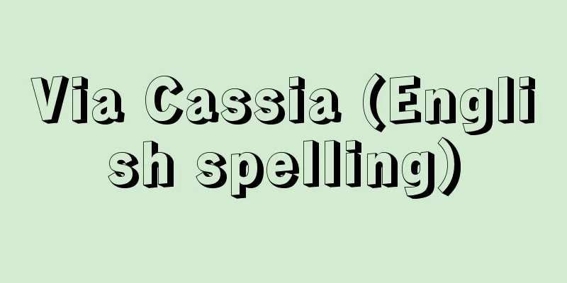
A lake in northeastern Hokkaido, straddling Abashiri City and Ozora Town. It stretches 11 km north to south, 4 km east to west, with a shoreline of 39 km, an area of 32.2 square km, an elevation of 0.0 m, and a maximum depth of 16.1 m. The surface is freshwater, but the bottom of the lake is salty, and it is believed to have been an inlet before the surrounding area became land. The Abashiri River flows into the south bank, forming a delta, and flows out from the north. Inland fishing is carried out by releasing smelt, crucian carp, and carp, and the fish are also processed. The wetland plant community in the Memanbetsu district of Ozora Town on the southeastern bank is a natural forest of deciduous broadleaf trees such as Japanese ash and Japanese alder, and a colony of Asian skunk cabbage continues on the forest floor for 2 kilometers, which has been designated a national natural monument. [Jiro Okamoto] This lake is located in eastern Hokkaido, south of Lake Notoro. It has an area of about 32 km and a maximum depth of about 16 m. It is surrounded by deep forests, and the Memanbetsu district's wetland plant community (a nationally designated natural monument) is home to a large number of Asian skunk cabbage and other plants. It is part of Abashiri Quasi-National Park. The photo shows the view from Mount Tento in the northeast. The Yobito Peninsula stretches out from the left. Abashiri City, Hokkaido and Ozora Town, Abashiri District ©East Hokkaido Tourism Business Development Council "> Lake Abashiri Source: Shogakukan Encyclopedia Nipponica About Encyclopedia Nipponica Information | Legend |
|
北海道北東部、網走市と大空町(おおぞらちょう)とにまたがる湖。南北11キロメートル、東西4キロメートル、湖岸線延長39キロメートル、面積32.2平方キロメートル、湖面標高0.0メートル、最深16.1メートル。表面は淡水であるが、湖底部には塩水があり、付近が陸化する以前は入り江であったと推測される。網走川が南岸に流入して三角州をつくり、北から流出している。ワカサギ、フナ、コイなどの放流による内水面漁業、その加工業も行われる。南東岸にある大空町女満別(めまんべつ)地区の湿生植物群落はヤチダモ、ヤチハンノキなどの落葉広葉樹の自然林で、林床にミズバショウの群落が2キロメートルにわたって続き、国の天然記念物に指定されている。 [岡本次郎] 北海道東部、能取湖の南に位置する湖。面積約32km、最大深度約16m。深い森林に包まれ、女満別地区の湿生植物群落(国指定天然記念物)にはミズバショウなどが群生する。網走国定公園に含まれる。写真は北東の天都山からの眺望。左側から呼人半島が延びる。北海道網走市・網走郡大空町©ひがし北海道観光事業開発協議会"> 網走湖 出典 小学館 日本大百科全書(ニッポニカ)日本大百科全書(ニッポニカ)について 情報 | 凡例 |


![Kaihosrou [II] - Kaihosrou](/upload/images/67cfef3e055dc.webp)

Recommend
Grylloblattidae yuasai (English name) Grylloblattidaeyuasai
…[Yamazaki Harane]. … *Some of the terminology th...
Knowledge and action
〘noun〙① To take charge of affairs. To execute one&...
Ujikoju - Shrine parishioners
〘 noun 〙 People who worship the same tutelary deit...
Repayment loan - Kangen Yuushi
Generally, in a contributory pension system, for a...
Critical concentration - GENKAINOUDO
A measure of the sensitivity of a detection react...
Japan Federation of Employers' Associations - Nihon Keieisha Dantairenmei
Founded in 1948, Nikkeiren is a national organizat...
Ujibashi San-no-Ma - Ujibashi San-no-Ma
...The quality of the water was one of the reason...
Earth pillar - Dochu
These soil pillars are formed mainly by rain eros...
Soluble coffee
…The inventor of instant coffee is said to be a J...
Minashiki - Kaishiki
...a lining placed on a dish when serving food. I...
Superior limit
If there is a sequence of real numbers { ai | i = ...
Kusazoushimono - Kusazoushimono
A type of Kabuki-Kyogen based on kusazoshi (combin...
Joint ride - Ainori Guruma
...Rickshaws became popular, and in February 1872...
Oinopion - Oinopion
…Son of the sea god Poseidon. He proposed to Mero...
Góngora (English spelling) Luis de Góngora y Argote
Spanish poet. Born in Cordoba as the son of a cul...