
African Great Rift Valley

|
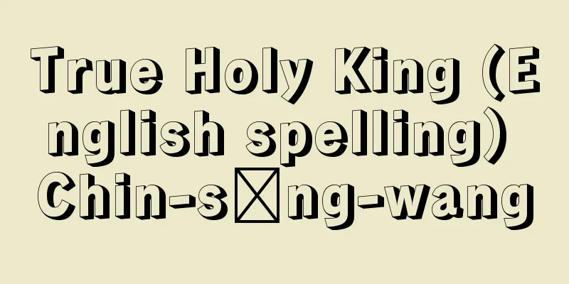
A series of fault-like depressions that run from the Jordan River Valley in Syria through the Dead Sea, the Gulf of Aqaba, the Red Sea, and the Ethiopian Plateau to Kenya, Tanzania, Malawi, and Mozambique. In the narrow sense, it refers to the area that stretches from north to south across East Africa, and consists of two rows, eastern and western. The eastern Kenyan side is simply called the Rift Valley, or the Gregory Rift Valley after its namer, Gregory, and the bottom of the rift is dotted with lakes such as Nakuru, Naivasha, and Magaji. The western side of Lake Victoria is called the Western Rift Valley, and contains Lakes Albert, Edward, Tanganyika, and Rukwa. The extension of the Western Rift Valley to Mozambique is called the Niassa Rift Valley, and Lake Malawi (Lake Niassa) is located at the bottom of the rift. The formation of these rifts (meaning fissures) is thought to be deeply related to the origin of ocean ridges, which are moving ocean floors according to the plate tectonics theory. Active normal fault earthquake and volcanic activity continues today, and surveys have observed east-west extension. In other words, the African plate is being torn apart by these rift zones. The "Rift Valley" is also the name of a region in central-western Kenya. [Nobuyuki Hori] ©Shogakukan "> Location of the African Great Rift Valley Source: Shogakukan Encyclopedia Nipponica About Encyclopedia Nipponica Information | Legend |
|
シリアのヨルダン川の谷から、死海、アカバ湾、紅海、エチオピア高原を抜け、ケニア、タンザニア、マラウイ、モザンビークへ続く断層による谷状の凹地列。狭義には東アフリカを南北に連なるものをいい、東・西の2列からなる。東のケニア側のものを単にリフト・バレー、または命名者グレゴリーにちなみグレゴリー・リフト・バレーとよび、地溝底にはナクル、ナイバシャ、マガジなどの湖が点在する。ビクトリア湖の西側のものを西リフト・バレーといい、アルバート、エドワード、タンガニーカ、ルクワの湖が分布する。西リフト・バレーのモザンビーク側への延長部をニアサ・リフト・バレーとよび、地溝底にマラウイ湖(ニアサ湖)がある。これらリフト(地裂の意)の形成は、プレートテクトニクス理論による動く海洋底としての、海嶺(かいれい)の成因と深いかかわりをもっていると考えられる。現在も活発な正断層型の地震活動と火山活動が続いており、測量でも東西方向の伸長が観測されている。すなわち、アフリカプレートはこの地溝帯によって裂けつつある。なお、「リフト・バレー」はケニア中西部の地方名称にもなっている。 [堀 信行] ©Shogakukan"> アフリカ大地溝帯位置図 出典 小学館 日本大百科全書(ニッポニカ)日本大百科全書(ニッポニカ)について 情報 | 凡例 |
<<: Africa Expedition - Africa Exploration
>>: African elephant (English spelling) Loxodonta africana; African elephant


![Nima [town] - Nima](/upload/images/67cc71b1b25f6.webp)


Recommend
tombeau
…It has a slower tempo than a normal march to mat...
Fujiwara Tadahira - Fujiwara no Tadaya
Year of death: 3.8.14 (949.9.9) Year of birth: 4th...
Kirizumi Shimada - Kirizumi Shimada
...The late Edo period was a time of centering on...
Kintaro candy - Kintaro candy
...Sankan-ame, a specialty of Edo and Kokura in B...
Autobaileya
…(3) The xylem of the vascular bundles contains v...
Tarbes - Tarbes (English spelling)
The capital of the Hautes-Pyrénées department in ...
Nematoda
...Also called nematodes. A general term for inve...
Oogee - Oogee
...Haya, Honbaya (Tokyo), Kuki (Gunma Prefecture)...
Adolf von Harnack
A representative German Protestant church histori...
King Eider (English spelling)
…A general term for the eider family Anatidae, or...
Zerubbabel
…Haggai was a prophet who lived after the Babylon...
Identification
〘noun〙① To determine that something is the same. ※...
Kurfürstendamm (English spelling)
...Berlin, which had a population of 3.86 million...
Guinevere - Guinevere
…Using the power of the wizard Merlin, King Uther...
Masataka Takemoto - Takemoto Masataka
A Gidayu performer. Along with his stage name Tak...